English-speaking world

Showing posts with label Oceania. Show all posts

18 May 2024

TONGATAPU

 WHERE TIME BEGINS

 Nudging the international dateline, in a time zone of its own, the Kingdom of Tonga is the first land to see the dawn of each new day. Tonga is unique. It's an independent constitutional monarchy and the only South Pacific country never to have been colonised. Because of this independence, the way of life has remained largely unchanged and culturally intact. The people are carefree, funloving and renowned for their sincere goodwill. Tonga still remains far away from it all, still different, still alone, and to the joy of those who find their way to the Kingdom - essentially unspoilt.

 
Tongatapu

 
The Kingdom of Tonga is made up of some 170 small islands. The administrative and shopping centre is the major town of Nuku'alofa on the largest island - Tongatapu. The atmosphere is often langourous, heady with the perfume of tropical flowers. Here you can still experience the freedom, the magic of being the only soul, idling along a creamy beach and enjoying the natural beauty of an unpolluted environment. The sights are many and varied, natural and historical. To absorb the ambience of Nuku'alofa a walking tour is a must.


13 April 2024

LINDIS PASS

 The main inland link between Otago and the Waitaki Basin, the Lindis Pass climbs through rocky gorges before reaching the tussock-covered hills of a Department of Conservation reserve near the summit. Early Māori, like today’s holidaymakers, used the route in summer to get to Lakes Wanaka and Hawea. In 1858, John McLean, the first European to settle in the area, established the 2,000 sq km (772 sq mile) Morven Hills Station. Many of the original buildings can still be seen about 15 km (9 miles) south of the summit. These include McLean’s original homestead and a massive stone woolshed, built about 1880, which was capable of holding up to 1,500 sheep.

Lindis Pass, South Island, New Zealand

Lindis Pass, South Island, New Zealand
The dramatic Lindis Pass links the Mackenzie region with Central Otago and is crossed during the drive between Christchurch and Queenstown.


Received from Roman

03 March 2024

OTIRA VIADUCT

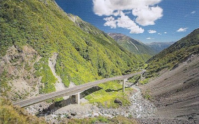
Straddling the Southern Alps 153 km from Christchurch and 98 km from Greymouth, the 1,147 sq km  Arthur’s Pass National Park, the seventh largest in the country, is a place of huge geological and climatic contrasts. On the western side of the alps, where the rainfall is high, the park is clad in dense and varied rainforest through which steep, boulder-strewn rivers rush; on the drier eastern side, mountain beech forests and tussock-covered river flats predominate. Sixteen mountain peaks in the park exceed 2,000 m.

Otira Viaduct, Arthur's Pass National Park, Canterbury

 Otira Viaduct, Arthur's Pass National Park, Canterbury


The park offers the well-equipped outdoor enthusiast superb mountain climbing and hiking opportunities, as well as many shorter walks suitable for people of all ages and fitness levels. Otira Viaduct completed in 1999, this section of State Highway 73 spans the rugged Otira River. The TranzAlpine journey from Christchurch to Greymouth crosses the Canterbury Plains before cutting dramatically through the Southern Alps via the Otira viaduct.


Received from Roman 

10 February 2024

RAROTONGA

 An Unforgettable South Pacific Experience!


The Cook Islands consist of 15 islands scattered over some 2 million square km of the Pacific Ocean. An unspoiled paradise, complete with white sand beaches, blue lagoons, and lush green mountains. The Cook Islands enjoy a pleasantly warm and sunny climate all year round. The hospitality is warm and spontaneous, the dancing exuberant, the mood relaxed. The old culture lives on with song, dance and an easy pace of life uncomplicated by the turmoil of the outside world. 

Cook Islands, Rarotonga

 BEAUTIFUL MURI BEACH AND LAGOON,
Rarotonga, Cook Islands


  Rarotonga, the hub of the Cook Islands, has so much to see and do, yet remains unspoilt. No traffic lights, no McDonald’s and no building taller than the highest coconut tree. Round Rarotonga Road Race (32 km, first Saturday in November) is extremely popular and many international runners participate. Rarotonga offers an interesting variety to tempt the taste buds from high class eateries to friendly "island style" cafes. Don't miss special "Island Night" cultural show for an unforgettable experience!

COOK ISLANDS TOURISM

01 July 2023

LUGANVILLE

 Espiritu Santo, more commonly known as Santo, is the largest island in Vanuatu with an overall area of some 4000 km². For the most part, the population lives along the coast or on the small offshore islands. Dominated by Mount Tabwemasana (1880 m) the eastern coast is wild and mountainous, difficult to access, as opposed to the western coast which can easily be explored. Copra, cattle farming, fishing, coffee and cocoa remain the major resources of the island, with a growing tourism sector.

Luganville

 
Luganville is Vanuatu's second urban centre. Whilst it may not be the administrative capital, nevertheless, with the extension of the airstrip to international standards and the various projects which should be coming on line shortly, not to mention the thousands of hectares of arable land, it stands a very good chance of becoming the economical capital of Vanuatu one day.

23 August 2020

NAPIER

Napier city is located in the Hawke's Bay region of New Zealand, around 6 hours driving time south from Auckland. Perched on the edge of the Pacific Ocean, this elegant city is a memorial to a 1931 earthquake and fire that destroyed most buildings and killed many people. Napier is known as the Art Deco Capital of the world. It is enhanced by palms and the angular Norfolk Island pines and bounded by fertile fruit and grape growing plains, dramatic hills and the shores of the South Pacific. In Napier, you can enjoy the legacy of its brave rebuilding and savour the spirit of the optimistic Art Deco era. Nowhere else can you see such a variety of buildings in the styles of the 1930s. 


Napier


26 July 2020

HAMILTON

The gateway to the Central North Island, Hamilton is New Zealand’s largest inland city, straddling the superb Waikato River. With a young, smart and innovative population, Hamilton's warm and welcoming spirit, rich history and contrasting splendours ensure visitors are spoilt for choice for places to relax, enjoy and do business. From magnificent parks and gardens to a thriving cultural precinct, the city offers a vibrant combination of fine dining and nightlife options as well as an eclectic mix of leisure, lifestyle and activity choices.


Fast facts

  • NZ's largest inland city.
  • NZ's longest river, the Waikato, flows for 16 kilometres through the city.
  • Hamilton's population ranks fourth in the 67 districts in NZ.
  • Has a youthful population - around half of residents are less than 30 years old.
  • NZ European make up three quarters of the population and Maori 19 per cent.
  • The city is home to more than 80 ethnic groups.
  • Mild climate and moderate year round rainfall keep the city and surrounding area very green.
  • 145 parks and gardens and 63 sports areas.
  • The city has more than 1,000 hectares of open space.
  • Three international sports venues – the multi-purpose FMG Stadium Waikato, the boutique international cricket ground Seddon Park, and indoor sport venue Claudelands.


Tourist Information: Visit Hamilton

06 August 2016

WELLINGTON

New Zealand's capital since 1865, Wellington is situated on the south-west tip of the North Island. Featuring a magnificent harbour and panoramic views from the surrounding hills, Wellington is a city of contrasts, offering a wide variety of commercial, cultural and recreational activities.


Background: Wellington from Northland. Top right: 'The Beehive'. Bottom from left: Cable car, City and Harbour, Carter Fountain.


In some ways it is similar to Naples, though it is only about one quarter the size. It is built on steep hillsides surrounding a large natural harbour and there is a cable car running up to the top of Mount Victoria. It is also close to a volcanic area. Wellington is a major port as well as a major financial and artistic centre, and has a vibrancy not found in any other New Zealand city.


Wellington at Dusk. This beautiful harbour retains New Zealand's seat of government, and is a major port facility for the lower North Island.


Known primarily as the home of New Zealand’s parliament and its public servant population, Wellington transformed itself during the 1980s and 1990s into a vibrant, culture-driven hot spot. Tucked around one of the world’s most picturesque harbours, the capital city is intimate, sophisticated, arty and packed with national treasures.


Aerial View showing Paremata, Mana, Plimmerton, Porirua Harbour and in the background, Kapiti Island, North Island, New Zealand.


Postcards received from Kelly - Wellington resident

03 June 2016

PORT VILA

Located in the Pacific Ocean, Vanuatu is made up of more than 80 islands and islets. Pacific islands of extraordinary beauty and fascination. Fragrant blooms of the tropic abound. Fringed by tall palms, white sand beaches remain unspoilt and uncrowded. The tourquoise waters of lagoons sparkle under a warm sun. This is the home of a proud people who still honour and nurture culture rich in age-old traditions and ceremonies. 


Port Vila, the capital city of Vanuatu, projects the image of a very cosmopolitan town with its mixture of European, Vietnamese, Chinese and Melanesian cultures. Alongside the modern two or three-storey buildings, the large colonial houses are reminders of a none too distant past. Not to be missed, the big market on mornings. 


Another heritage of those times, the bustling Chinese district, where you can find everything you could imagine "made in Hongkong" at very reasonable prices. Most of the commercial life is in the main street (Kumul Highway), with duty-free shops, coffee shops, restaurants, fashion boutiques, travel agencies, but also the banks and many other establishments.

06 November 2015

COCOS KEELING ISLANDS

The Cocos (Keeling) Islands are located in the Indian Ocean 2950 kilometres north-west of Perth and 3700 kilometres west of Darwin. There are 27 coral islands in the group with a total land area of approximately 14 square kilometres. Only two of the 27 islands are inhabited. Australia's last unspoilt paradise lies in the azure waters of the Indian Ocean, kissed by the sun and caressed by fragrant trade winds.


Apart from North Keeling Island (declared a National Park in 1995 and is administered by Parks Australia), which is 30 kilometres from the main group, the Islands form a horseshoe-shaped atoll surrounding a lagoon. The people of the Cocos Keeling Islands voted to become part of Australia in 1984.


On the stamps:
  • The Herald Petrel (Pterodroma arminjoniana) is a medium-sized bird belonging to the Procellariidae family. It is a sea bird and spends much of its life on or above the ocean, only really visiting nesting grounds during breeding season.
  • Home Island - located across the lagoon and just a short ferry ride away, this unique part of the Cocos Keeling Islands is a must-see for visitors. Home of the Cocos Malay people, the island offers a complete contrast to West Island.


Received from Cocos Keeling Islands Visitor Centre

02 October 2015

MARSHALL ISLANDS

The Republic of the Marshall Islands is one of only four atoll nations in the world and is also one of the world’s youngest nations, independent only since 1986. The Marshall Islands consists of 29 atolls each made up of many islets and 5 islands in the central Pacific between 4 degrees and 14 degrees north, and 160 degrees and 173 degrees east. The atolls and islands are situated in two almost parallel chain-like formations known as the Ratak (Sunrise or Eastern) group and Ralik (Sunset or Western) group. 


The Republic of the Marshall Islands covers nearly a million square miles of picturesque islands, thriving coral atolls, and crystal clear blue waters … undoubtedly one of the most interesting places in the world to visit. Marshall Islanders are known throughout the Pacific and the world for their friendly and peaceful nature. Both Marshallese and English are the official languages of the Marshall Islands.


Capital: Majuro Island, Majuro Atoll
Political Status: Self-governing democracy in free association with the U.S.

Currency: U.S. dollar


Received from Marshall Islands Visitors Authority

01 August 2015

CHRISTMAS ISLAND

Christmas Island is an island in the Indian Ocean, about 1,400 km northwest of Australia. Captain William Mynors of the East India Ship Company vessel, the Royal Mary, named the island when he arrived on Christmas Day, 25th December, 1643. It is administered as an external territory of Australia. The island is the summit of an oceanic mountain whose highest point on the island is Murray Hill, rising to 361 metres in the western part of the island. The island is only 52 square-miles in area. The main settlement and chief port is at Flying Fish Cove on the northeastern part of the island.

 Flying Fish Cove

Christmas Island is an impressive feat of nature full of natural wonders including red crab migrations, exotic birds and wonderfully deserted beaches who are only disturbed by nesting sea turtles. Fourteen species of land crab call Christmas Island home, but the red crab is by far the most famous. The narrow tropical reef that surrounds the island is laced with unspoiled corals and schools of colourful fish like anemones, butterfly fish, wrasse, surgeon and more. Occasionally, even sharks come up to divers to take a curious look.

fabulous stamps


11 July 2015

NORFOLK ISLAND

 Norfolk Island is an island in the South Pacific Ocean and an Australian territory for historical reasons even though it is much closer to New Zealand. It is 1600km east of Sydney and Brisbane but only 1000km northwest of Auckland. The official language of Norfolk Island is English and all the islanders speak it. However, among themselves they often use Norfolk, a language derived from the English spoken by the Bounty Mutineers and the Tahitian spoken by their wives. 


The main attraction of the island consists of natural beauty: beautiful landscapes and wild seascapes. Almost a third of the island is devoted to reserves and national parks. The beaches need a mention as well, the cleanest salt water and softest sand imaginable, the surf here is pretty good too. Another fascinating aspect of Norfolk's heritage is that this is the home of the descendants of the mutineers of the Bounty.


Received from Norfolk Island Tourism.


09 February 2015

CHRISTCHURCH

Christchurch is New Zealand's second-largest city and the gateway to the South Island. Bordered by hills and the Pacific Ocean, it is situated on the edge of the Canterbury Plains that stretch to the Southern Alps. Located on the east coast of the South Island, Christchurch is a city of contrasts.It is a place where its residents continue to enjoy a healthy, active lifestyle amidst a natural environment world-renowned for its beauty. A growing cosmopolitan ambience also adds a touch of excitement without overt flashiness.


The 'Sign of the Takahe' - Christchurch New Zealand


This unique Gothic style building was conceived by Mr. H. G. Ell in 1918 as a roadhouse for the refreshment of travellers along the scenic Port Hills. I was constructed with primitive tools by relief workers during the 1932 depression and commands a panoramic view of the city, the Plains and the Southern Alps. The roadhouse is open daily for inspection and refreshments.

20 December 2014

DUNEDIN

Dunedin is New Zealand’s largest city by area and arguably the most spectacular in terms of contrasting landscapes. Dunedin is a thriving city set amidst a magical landscape edged by the sea. It’s a place where the streets hum vibrantly with colour and culture, and the beauty of nature is everywhere. Setting it apart from other New Zealand cities, Dunedin has the finest examples of Victorian and Edwardian architecture in the Southern Hemisphere. It has close historical links with the Scottish city of Edinburgh. 


Dunedin, Otago, NZ


The city is renowned for its proximity to incredible wildlife and is often referred to as the eco-capital of New Zealand. The 24 km-long Otago Peninsula (19000ha) is home to a colony of one of the world’s rarest penguins, stretching along the southern edge of the Otago harbour is an easy drive from central Dunedin. Dunedin is a city of rare and charm.

02 August 2014

AUCKLAND

Auckland is the largest city in New Zealand. It has a population of just under a million people and is located on North Island. This seaport is an important centre for business and industry. It is also the most dynamic and multicultural city in New Zealand. The history of the city goes back 650 years when the Maoris settled in the area. European settlement began in 1840 when the British arrived. New Zealand's first governor, Captain William Hobson, made Auckland the capital. Later, the capital moved to Wellington, because it was more central. Since 1945, the city of Auckland has grown and it now has large modern suburbs.


Auckland Waterfront, New Zealand. The ever-changing skyline of New Zealand's largest city is seldom better depicted than from the placid waters of the Waitemata Harbour.

Famous sights include Mt Eden, one of the many volcanic hills, as well as the Auckland Harbour Bridge. At the Parnell Village you can visit some of the first European settlers' homes. In the city is the beautiful Auckland Domain which is famous for its large palm trees and exotic plants. You can see Maoris perform their traditional dances at the Auckland Museum.
From wherever you are in the city, you can see the sea. Auckland's nickname is 'the city of sails' because it has more boats than anywhere else in the world. It has a warm climate with plenty of sunshine.